Geography


Geography at Stockbridge Village Primary
‘You can travel the seas, poles and deserts and see nothing. To really understand the world, you need to get under the skin of the people and places. In other words, learn about geography. I can’t imagine a subject more relevant in schools.’
Michael Palin
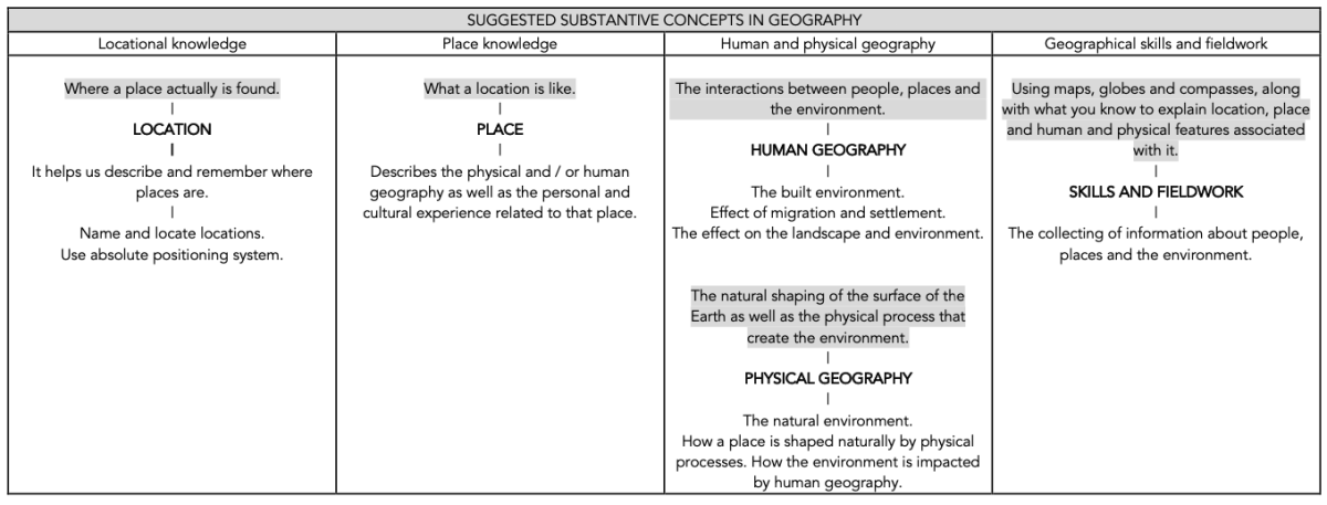
At SVP, it is our intention that when children study geography they will consider themselves as practising the skills of the geographer. Children will have access to knowledge that develops their understanding of the manmade and natural world, including continents, countries, oceans, climates and cities and settlements. Children will be introduced to the knowledge and skills of geography and be given the opportunity to practise skills using relevant equipment and resources. The acquisition of subject specific vocabulary is essential for developing understanding and acquiring the voice of the geographer.
As the children progress through the school, resources and practical activities, including the use of compasses, globes, maps, keys will help consolidate classroom learning. Children will acquire the ability to compare and contrast geographical places and locations and to make reasoned and evidence based judgements about those differences. The curriculum aims to inform children about the world they inhabit so that they can make sense of what they see around them.
Our geography lessons follow an essential component to CUSP lessons which is the systematic and coherent approach that we embed, focusing on the six phases of a lesson.
At SVP, we ensure that children experience a wide range of geographical knowledge, understanding and skills. We do this by:
1. Ensuring that the children have a substantial bank of substantive knowledge- this is the subject knowledge and explicit vocabulary used to learn about the content. Common misconceptions are explicitly revealed as non-examples and positioned against known and accurate content as pupils become more expert in their understanding. Misconceptions are challenged carefully and in the context of the substantive and disciplinary knowledge. In CUSP Geography, it is recommended that misconceptions are not introduced too early, as pupils need to construct a mental model in which to position new knowledge.
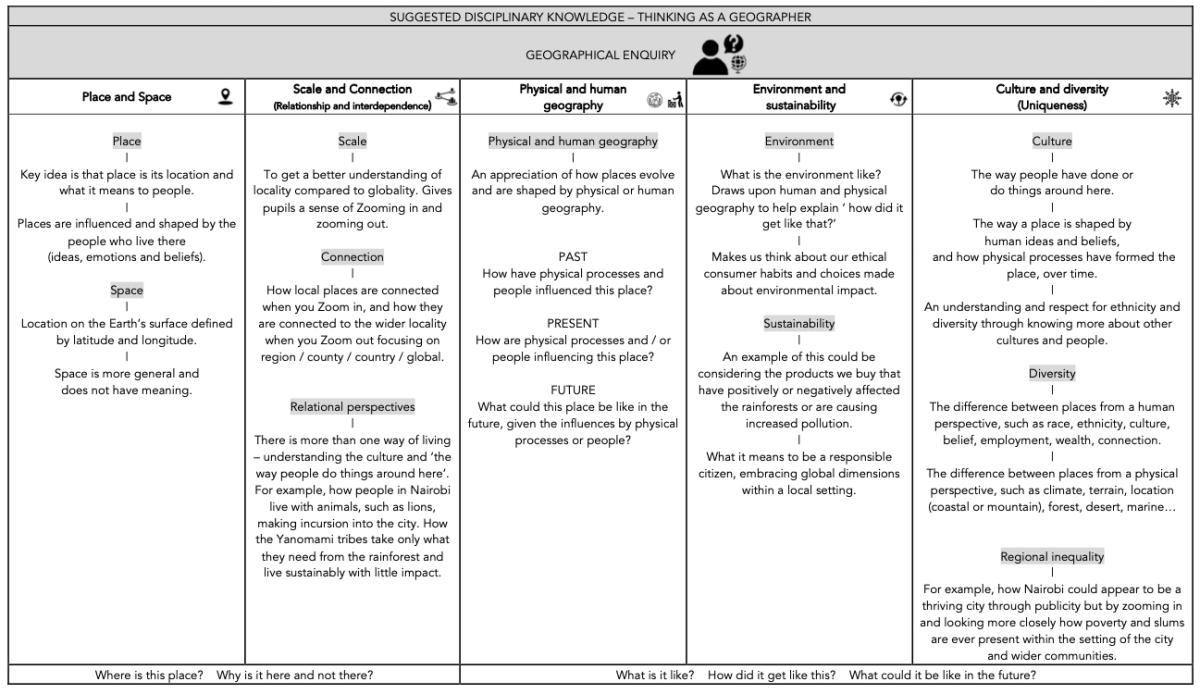
2. The children use disciplinary knowledge to explore and expand on substantive knowledge. This is known as Geographical Enquiry. This is the use of knowledge and how children become a little more expert as a geographer by Thinking Geographically. We use five strands of geographical enquiry to ensure children become experts.
Children are taught using the CUSP Geography scheme of work which ensures that we have full coverage of the National Curriculum whilst embedding pedagogical principles that ensure children can remember and retrieve information.
End Points
After each lesson, we use cumulative quizzes to ensure children have gained the required knowledge. Each unit of work has a series of end points with essential and desirable knowledge.
Vocabulary
Each unit of work has a range of Tier Two words (words that can be used across the curriculum) and Tier Three words (words that are subject specific). Children are taught new vocabulary prior to and during the lesson.
See the link below for end points and vocabulary for each unit.
EARLY YEARS
The Early Years Foundation Stage Curriculum supports children’s understanding of geography, people and communities through the planning and teaching of ‘Understanding the World’.
Children learn about features of their own environment such as school, home, community and their city through first hand experiences and learn how environments may differ through the sharing of books, stories, poems, small world play, role play and visits. Children enjoy the valuable experiences gained from our regular trips to places within their local community. Children are given time to discuss, comment and ask questions about what they observe about the world around them and are encouraged to be active learners and explore their interests further.
KEY STAGE 1
The sequence in KS1 focuses young children to develop a sense of place, scale and an understanding of human and physical geographical features.
Later in KS1, map skills and fieldwork are essential to support children in developing an understanding of how to explain and describe a place, the people who live there, its space and scale.
Initially, children study the orientation of the world through acquiring and making locational sense of the 7 continents and 5 oceans of the world. They extend their knowledge and study the countries and capital cities of the United Kingdom, along with the oceans and seas that surround us, routes and maps can be made concrete in day-to-day experiences in the safety of their school grounds and classrooms.
Throughout KS1, pupils enhance their locational knowledge by studying and identifying human and physical features of places and contrasting locations throughout the world. The location of these areas in the world are deliberately chosen to be culturally diverse.
Fieldwork and map skills are further developed with a study of the local area, using cardinal points of a compass. Maps are introduced through familiar stories as a way to communicate what the place and space is like. Pupils retrieve and apply knowledge about human and physical features in their local context. OS maps are introduced to pupils in KS1 using Digimap for Schools. Simple keys and features are identified and mapped locally to help begin to understand place, distance and scale.
LOWER KEY STAGE 2
As pupils begin KS2, fieldwork and map skills are revisited with the intercardinal points of a compass points being introduced to elaborate on the knowledge pupils already have around cardinal points. This supports a study of the UK, focusing on regions, counties, landmarks and topography. Further studies are undertaken to elaborate fieldwork and map skills through a sharper focus on OS maps.
Pupils elaborate and expand their understanding of human and physical features and apply it to the study of rivers.
To enable accurate location of places around the globe, pupils study absolute positioning or reference systems through latitude and longitude.
Complementing studies on location and position is the focus on the water cycle. It offers explanation and reason about physical processes as well as why certain biomes have specific features in specific global locations. Pupils study geographical patterns across the world using latitude of locations to explain why places are like they are. Further river studies revisit substantive knowledge and these are applied to the River Nile and the Amazon River.
Further fieldwork and map skills are introduced to enrich pupils’ disciplinary knowledge of locations and places.
A deliberately planned study focusing on the environmental regions of Europe, Russia, and North and South America draws attention to climate regions.
UPPER KEY STAGE 2
The study of Biomes and Environmental regions builds upon world locations, latitude and longitude studies. World countries and major cities are located, identified and remembered through deliberate and retrieval practice, such as low stakes quizzing and Two things tasks. The study of biomes is revisited deliberately to ensure the content is remembered and applied.
In upper KS2, the study of 4 and 6 figure grid references supports prior learning of reference systems and brings an increased accuracy to mapping and fieldwork skills.
Pupils take part in geographical analysis using patterns and comparison of both human and physical processes as well as the features present in chosen locations. This abstract concept is made concrete through studying and comparing the Lake District, the Tatra mountains of Poland and the Blue mountains of Jamaica. Physical processes such as orogeny and glaciation are acquired to explain significant change over long periods of time. The concept of physical process is revisited through a study of Earthquakes, mountains and volcanoes.